Parsons Road
Project Description
The Parsons Road Project includes the widening and associated intersection improvements of Parsons Road to three lanes between Central Avenue and W. Richardson Avenue to reduce traffic congestion, improve safety, and accommodate bicyclists and pedestrians.
Project Announcements
Project Fast Facts
Project Map
The blue outline on the map indicates the general vicinity for the transportation project. The boundary is for informational purposes only and does NOT indicate property impacts.
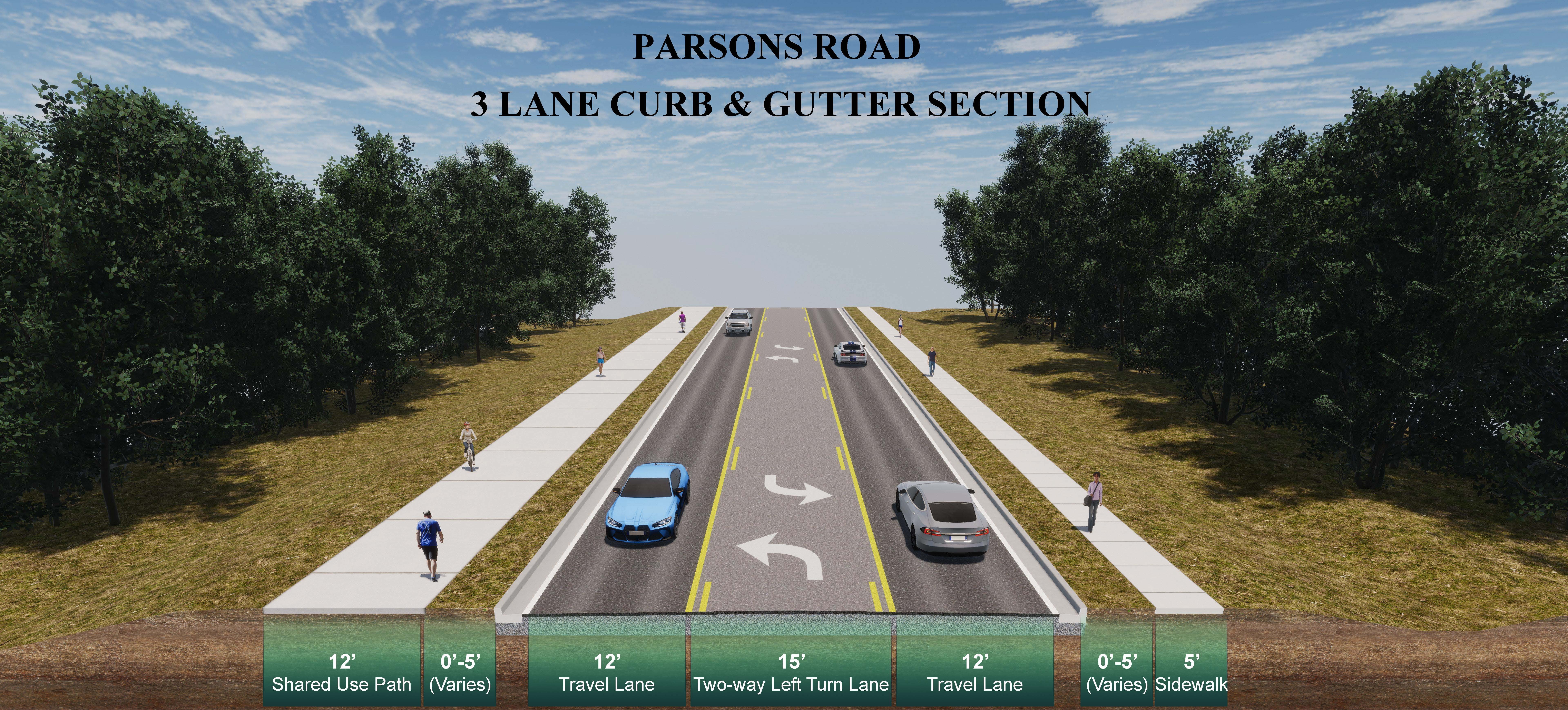
Proposed Road Section
Dashboard
The embedded Power BI Dashboards can be viewed in full screen by clicking the arrow  on the bottom right of the BI Dashboard. Press ESC to exit full screen and return to the Home page.
Project Announcements
Dorchester County held a public meeting on Thursday, April 23, 2026, from 5:00 to 7:00 PM at Alston-Bailey Elementary School, 820 West 5th North St, Summerville, SC 29483.
The meeting was a drop-in format, and no formal presentation was given. The purpose of the meeting was to provide updated information about the project’s preferred design alternative, and to solicit the public’s feedback. The Central Ave and Parsons Rd improvements projects include widening Central Avenue and Parsons Road between Orangeburg Road and W. Richardson Avenue, along with associated intersection improvements.
Comments from the public were accepted for a 30-day period following the public meeting. To access meeting materials and the online comment form after the in-person meeting, please visit DorchesterTransportation.com or email Transportation@dorchestercountysc.gov.
Environmental & Community Resources
A combined in-person Public Information Meeting (PIM) was held for the Central Avenue and Parsons Road Improvements Projects on June 10, 2025, from 5 -7 PM at the Alston-Bailey Elementary School in Summerville, South Carolina. In addition, project specific websites were hosted on Dorchester County’s website, allowing individuals to review materials and provide input at their convenience, thereby expanding access for those unable to attend in person.
The public was invited to submit comments and questions from June 10, 2025, through July 10, 2025. An overview of the comments received and responses to comment questions can be found on the project Public Meeting Summary page.
A public meeting was held for Central Ave & Parsons Road on June 10. The comment period closed on July 10. Thank you to everyone who attended the public meeting and/or provided comments as your feedback is valuable to the project development process. We have reviewed all comments received and they will be filed with our project records. You can view the meeting materials at the links below.
NOTICE TO CITIZENS OF DORCHESTER COUNTY: Pursuant to the South Carolina Eminent Domain Procedure Act, Section 28-2-70(c), Code of Laws of South Carolina, 1976, as amended, notice is hereby given that entry by personnel of, or working under contract with, Dorchester County (County) will be made in the area of the roads described below for such purposes as topographic surveys, subsurface exploration, environmental related studies and for the gathering of any other data necessary for the planning, design, property acquisition and construction of a roadway improvement projects. Surveys for the projects will be conducted on the following roads as described:
- S-13 (Central Avenue) between 500 feet west of the intersection with S-22 (Orangeburg Road) to 1,200 feet east of the intersection with S-59 (Parsons Road), including up 750 feet in either direction on intersecting roadways
- S-59 (Parsons Road) between S-13 (Central Avenue) and W. Richardson Avenue, including up to 400 feet in either direction on intersecting roadways
The project involves road widening and intersection improvements, and improvements to bicycle and pedestrian accommodations. This project is made possible by the Dorchester County Transportation Sales Tax Program. Information about the project may be obtained by contacting Dorchester County at Transportation@dorchestercountysc.gov or visiting https://dorchestertransportation.com/. Dorchester County Project IDs: 24TSCA, 24TSPR
- The Program’s project list was developed through a collaborative effort led by an Infrastructure Subcommittee, which was specifically formed for the Transportation Sales Tax (TST) initiative. This subcommittee brought together local leaders, planners, engineers, and elected officials, including representatives from Dorchester County government, the Town of Summerville, City of North Charleston, and the Greater Summerville/Dorchester County Chamber of Commerce. Working in coordination with the Berkeley-Charleston-Dorchester Council of Governments (BCDCOG), Berkeley County, and Charleston County, the committee aimed to identify and prioritize transportation projects that addressed critical infrastructure needs throughout the County.
- The Infrastructure Subcommittee provided a recommended list of projects to the Dorchester County Council, which reviewed the proposed transportation projects for their alignment with the County’s Comprehensive Plan, Strategic Plan, and infrastructure priorities. A public hearing was held on September 19, 2022, and the public’s feedback was used to further refine the list of projects, which were ultimately approved by Dorchester County Council through Ordinances 22-16 and 22-22 to levy and impose a one percent sales and use tax, subject to a referendum. On November 8, 2022, Dorchester County voters favored continuing the existing sales and use tax.
- Further, the Central Avenue and Parsons Road Improvements will connect with the recently completed Maple Street Improvements, upcoming US Highway 78 Phase 3A Improvements, and the future Orangeburg Loop project. This allows for a network level of improvements across Dorchester County.
- An initial Public Information Meeting was held June 10, 2025, to present the project scope, proposed design alternatives, project status, and anticipated schedule. The public was encouraged to provide feedback on the design alternative. A summary of this meeting can be found here.
- A second Public Information Meeting was held April 23, 2026 to provide an update on key project components based on the input received, preferred alternative, next steps and gather input on the project design.
The project will reduce future traffic congestion, improve safety, and accommodate bicyclists and pedestrians throughout the corridor.
- Reduce Traffic Congestion: This area currently experiences some traffic congestion and delays, particularly at the intersection of Central Avenue and Parsons Road. Future traffic projections show the AADT (Annual Average Daily Traffic) is expected to increase by 67% on Central Avenue and 86% on Parson Road by 2050. Therefore, the corridor is expected to reach a failing level of service by 2050 if no improvements are made. The proposed road improvements take into account future growth and traffic demands along the corridor and are designed to allow Central Avenue and Parsons Road to operate at an acceptable level of service through the design year of 2050.
- Improve Safety: Road safety, for all road users, is a critical concern in South Carolina. Statistics show that roads in South Carolina and our region are among the worst in the nation and state, respectively, for crashes and fatalities. Projects in the Transportation Sales Tax Program will be designed to improve safety throughout the corridor for all road users.
- **Source: NHTSA FIRST Database
- **Source: NHTSA FIRST Database
- Accommodate bicyclists and Pedestrians: Both the SCDOT and Dorchester County have adopted Complete Streets policies that require and encourage safe transportation for all users. All projects within our Transportation Sales Tax program include bike lanes and/or shared use paths in addition to sidewalks to accommodate both bicyclist and pedestrians along the corridor. By including these improvements in all of our projects, we are developing a network of multimodal connectivity throughout the County. More information on these policies can be found here:
- SCDOT Complete Streets Policy - adopted in February 2021
- Dorchester County Complete Streets Ordinance - adopted in January 2025
- Yes. The traffic analysis shows that without improvements, key intersections, including Orangeburg Road at Central Avenue, Butternut Road at Central Avenue, and Parsons Road at Central Avenue, are projected to exceed their capacity and operate in failing conditions by 2050. See table of Traffic Data here: https://dorchestertransportation.com/application/files/8617/4957/4822/Traffic_Data.pdf
- This project is designed to improve traffic flow and enhance performance at major intersections within the project area.
- The project team follows the procedures of the South Carolina Department of Transportation (SCDOT) Traffic Noise Abatement Policy, which was developed to meet Federal Highway Administration (FHWA) requirements.
- As a part of the preliminary design development process for this project, a traffic noise impact analysis was completed to study the existing noise levels and future projected noise levels along the entire corridor. The purpose of the analysis is to evaluate whether noise abatement measures need to be considered as part of the project to help reduce noise impacts that would result from the project.
- Results of the noise impact analysis show that a limited number of locations along Central Avenue and Parsons Road would be impacted by noise as a result of the widening projects. Preliminary design studies also found that a noise barrier wall would be both ‘feasible and generally reasonable’ to construct per the Noise Abatement Policy. These findings are preliminary and do not guarantee that a noise-reducing measure will be constructed. A final decision regarding the installation of an abatement measure will be made upon completion of the project design and the ongoing public involvement process.
Please Note: The project team will directly contact any anticipated impacted property owners. Additional information about the noise impact analysis process and findings will be available at the public information meeting on March 23, 2026 and online following the meeting.
What Comes Next?
A final decision regarding the installation of noise mitigation measures will be made upon completion of the project design and will include a vote for all property owners impacted by potential noise walls. Opportunities for public input will continue as design progresses, and final noise wall decisions will be communicated to affected residents.
- Dorchester County’s Zoning and Land Development Standards 04-13, Section 5.4.8 (Setbacks from Designated Corridors) requires developments to be constructed with setbacks and buffer yards measured from the future right-of-way established for designated transportation projects such as Central Avenue or Parsons Road.
- The Preferred Alternative plans presented at the Public Information Meeting in April 2026 show the proposed improvements and future right-of-way locations. These plans are subject to change as the design progresses and as the County works to minimize impacts through further development of the engineering plans.
- As the design is further developed, right-of-way plans will need to be approved by the SCDOT. Once approved, the SCDOT will issue the County authorization to move forward with right-of-way acquisition. It is important to remember that right-of-way is not only needed for road improvements, but also other infrastructure improvements that are included in these projects such as the construction of sidewalks or shared use paths, drainage improvements, and utility relocations.
- If right-of-way needs to be obtained from your property due to a transportation improvement project, a right‑of‑way agent contracted through Dorchester County will contact you directly to explain the formal process and next steps at that time. To learn more about your rights and available resources, you may review SCDOT’s Highways and You Brochure.
Partial Property Acquisition (Partial Take)
Portions of private properties (typically referred to as strip takes) may need to be acquired in order to construct and maintain the transportation project. This area could be used for widening, drainage, or utility improvements and could be purchased as an easement or in Fee Simple. In these situations, you will receive compensation both for the land acquired and for any impacts to the remaining property, if applicable. When this occurs, the right‑of‑way agent will make an offer for the fair market value of the property based on an appraisal. The right‑of‑way agent will review the appraisal with you and explain how the value was determined. If adjustments to driveways, landscaping, or access are required, the project team will work with you to minimize disruptions.
Full Property Acquisition (Full Take)
In some cases, a transportation project may require the purchase of an entire property. When this occurs, the right‑of‑way agent will make an offer for the fair market value of the property based on an appraisal. If relocation is necessary, residents are eligible for relocation assistance benefits such as help finding a new home, reimbursement for closing costs, moving costs, and, when applicable, supplemental payments to ensure access to comparable replacement housing. All services are provided at no cost to the property owner or tenant, and the goal is to make the transition as smooth and equitable as possible. Any resident who must relocate due to a Transportation Sales Tax project is protected under the Uniform Relocation Assistance and Real Property Acquisition Policies Act of 1970, as amended (42 U.S.C. 4601 et seq.). These federal protections guarantee fair and consistent treatment, just compensation, and assistance during the moving and relocation process.
- Yes, the Central Avenue and Parsons Road Improvements projects are both fully funded through construction by the Transportation Sales Tax Program.
- Yes. Since both projects are in similar stages in the schedule, constructing them together will help reduce construction costs and overall disruption time to the traveling public.