Stallsville Loop
Project Description
The Stallsville Loop Project includes the realignment of Stallsville Loop and associated intersection improvements from its existing intersection with Old Trolley Road to align with the intersection of Old Trolley and Miles Jamison Road to reduce congestion and improve traffic flow. The proposed project also includes accommodations for bicyclists and pedestrians.
The blue outline on the map indicates the general vicinity for the transportation project. The boundary is for informational purposes only and does NOT indicate property impacts.
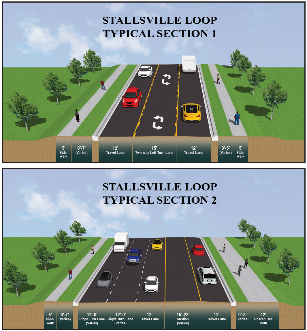
Proposed Road Section
Dashboard
The embedded Power BI Dashboards can be viewed in full screen by clicking the arrow  on the bottom right of the BI Dashboard. Press ESC to exit full screen and return to the Home page.
Project Announcements
An in-person Public Information Meeting (PIM) was held for the Stallsville Loop Project on September 30, 2025, from 5 -7 PM at Stallsville United Methodist Church in Summerville, South Carolina. The meeting was conducted drop-in style to provide flexibility and maximize opportunities for attendance. Project representatives were present to engage with attendees and answer any questions. The PIM was well-attended, with 94 individuals having signed into the meeting.
The public was invited to submit comments or questions via the project website, mail, email, or in person at the PIM. A total of 50 responses were received during the comment period from September 30, 2025, through October 30, 2025. An overview of the comments received and responses to comment questions can be found on the project Public Meeting Summary page.
An informal, drop-in Public Information Meeting regarding the Stallsville Loop improvements project was held on Tuesday, September 30, at Stallsville United Methodist Church. The meeting's purpose was to provide the public with information about the project scope, proposed design, project status, and anticipated schedule. There was no formal presentation at the meeting. Attendees had the opportunity to ask questions and share feedback with project representatives through Tuesday, October 30.
NOTICE TO CITIZENS OF DORCHESTER COUNTY: Pursuant to the South Carolina Eminent Domain Procedure Act, Section 28-2-70(c), Code of Laws of South Carolina, 1976, as amended, notice is hereby given that entry by personnel of, or working under contract with, Dorchester County (County) will be made in the area of the road(s) described below for such purposes as topographic surveys, subsurface exploration, environmental related studies and for the gathering of any other data necessary for the planning, design, property acquisition and construction of a roadway improvement project. Surveys for the project will be conducted on the following road(s) as described:
- S-9 (Stallsville Loop) between Long Needle Lane and S-199 (Old Trolley Road), including up to 200 feet in either direction on intersecting roadways
- S-199 (Old Trolley Road) from approximately 500 feet north of Stallsville Loop to approximately 1000 feet south of Stallsville Loop
The survey limits will also include approximately 3.5 acres in the southwest corner of the intersection of Stallsville Loop at Old Trolley Road.
The project involves roadway realignment and intersection improvements, as well as improvements to bicycle and pedestrian accommodations. This project is made possible by the Dorchester County Transportation Sales Tax Program. Information about the project may be obtained by contacting Dorchester County at Transportation@dorchestercountysc.gov or visiting https://dorchestertransportation.com/. Dorchester County Project ID: 24TSSL